
EMBRACING ENTROPY / Å ØNSKE ENTROPIEN VELKOMMEN
Exploratory concepts for the transformation of a post-coal mining landscape / Utforskende konsepter for transformasjon av landskapet etter kullgruvedrift
Written by Thomas Juel Clemmensen, translated by Språkverkstaden
It seems that then they made up the laws for mining reclamation they wanted to put back the mines the way they were before they mined them. Now that’s a real Humpty Dumpty way of doing things. (…) It seems that the reclamation laws really don’t deal with specific sites, they deal with a general dream or an ideal world long gone. It’s an attempt to recover a frontier or a wilderness that do no longer exists. Here we have to accept the entropic situation and more or less learn how to reincorporate these things that seem ugly. (1.)
Robert Smithson
A landscape architectural perspective on mining reclamation
In 2019 I was responsible for a master's course in landscape architecture at the Academy of Arts in Tromsø (2.). In this course dealing with landscape transformation, we worked with alternatives to the proposed mining reclamation or “clean-up” project at Svea, launched by the Norwegian Government in 2018. In accordance with the Svalbard Environmental Protection Act from 2002, one of the main objectives of this project is to restore the mining area to its original condition as far as possible (3.).
Svea was chosen as a case study because the proposed project demonstrates some dilemmas and paradoxes associated with landscape restoration and mining reclamation. Not only do the active geologic forces on Svalbard bring attention to the dynamic character of landscapes, which raises questions about originality and what to restore or reclaim. The project also highlights the artificial distinction between natural and cultural heritage.
Why are landforms and ground material conditions not considered part of the cultural heritage? Should ecological niches following human interventions be protected or removed? Based on such questions, the main task of the course was outlined. Rather than addressing how to clean the mining area, the task was to clarify existing nature-culture assemblages and develop exploratory concepts for new stronger “nature-cultures”, which exemplify how to live with the material legacy of coal mining at Svea in a meaningful way (4.).

Figure 1. One of the more distinctive material features of the post-mining landscape at Svea is the black waste material known as skeidestein. This massive landfill with skeidestein was situated at Lundbakken north of the mining settlement. (Photo: Thomas Juel Clemmensen).
Entropy and the material legacy of coal mining
One of the more distinctive material features of the post-mining landscape at Svea is the black waste material known as skeidestein, a material that looks a bit like coal. Then doing fieldwork at Svea, we experienced how this material could be found all over the landscape in different conditions and quantities. There were smaller collections with thin layers of particles distributed by wind and water and more significant humanmade deposits.
At Lundbakken, north of the mining settlement, we visited a massive landfill with skeidestein. Here the authorities were testing a camouflage strategy as part of the reclamation project (see fig. 1-2). By covering the black material with rocks from the neighbouring mountainside, the waste deposit is supposed to blend more into the surroundings. Apparently, it is too difficult or expensive removing such quantities even for an ambitious project with an estimated budget of 2,5 billion NOK.
We wanted to challenge this attitude towards the black waste material in the course. Echoing the American artist Robert Smithson (5.) we wanted to accept the entropic situation and reincorporate the black waste material in the future visions for the post-mining landscape at Svea. According to the concept of entropy, specific processes are irreversible or impossible (6.). Returning a mining area to its pre-mining condition or pouring asphalt down a quarry can be seen as such (7.).
Instead of considering the black waste material foreign to the landscape, we saw it as an essential and natural part of the material legacy of more than a hundred years of coal mining at Svea – something now belonging to the specific landscape. Therefore, we wanted to explore alternatives to cleaning and hiding. In the following student projects, the black waste material and other humanly modified materials are used as landscape architectural markers and active components in the local ecosystem (8.).
Et landskapsarkitektonisk perspektiv på tilbakeføring etter gruvedrift
I 2019 var jeg ansvarlig for et masteremne i landskapsarkitektur ved Kunstakademiet i Tromsø (2.). I dette emnet, som omhandlet landskapstransformasjon, jobbet vi med alternativer til det foreslåtte tilbakeføringsprosjektet eller «oppryddingsprosjektet» i Svea, som ble lansert av regjeringen i 2018. I samsvar med Svalbardmiljøloven av 2002 er et av hovedmålene med prosjektet å tilbakeføre gruveområdet til dets opprinnelige tilstand så langt det er mulig (3.).
Svea ble valgt som studieobjekt fordi det foreslåtte prosjektet eksemplifiserer en del dilemmaer og paradokser knyttet til landskapsrestaurering og tilbakeføring av gruvelandskap. Ikke bare retter de aktive geologiske kreftene på Svalbard oppmerksomheten mot landskapets dynamiske karakter (noe som reiser spørsmål om originalitet og hva som skal restaureres eller tilbakeføres) – prosjektet synliggjør også det kunstige skillet mellom natur- og kulturarv.
Hvorfor regnes ikke landskapsformer og grunnmateriale som en del av kulturarven? Bør økologiske nisjer etter menneskelige inngrep beskyttes eller fjernes? Disse spørsmålene dannet grunnlag for emnets hovedmål. I stedet for å ta opp hvordan gruveområdet kunne gjøres rent, var oppgaven å få oversikt over eksisterende natur-kultur-samlinger og utvikle utforskende konsepter for nye og sterkere «naturkulturer» som eksemplifiserer hvordan man kan leve med den materielle arven fra kulldriften i Svea på en meningsfylt måte (4.).

Figure 2. As part of the reclamation project, the authorities tested a camouflage strategy at the Lundbakken landfill. By covering the black material with rocks from the neighbouring mountainside, the waste deposit is supposed to blend more into the surroundings. (Photo: Thomas Juel Clemmensen).
Entropi og den materielle arven fra kullgruvedriften
Et av de mer karakteristiske materielle trekkene ved landskapet i Svea etter gruvedriften er det svarte avfallsmaterialet skeidestein, et materiale som ligner litt på kull. Da vi gjorde feltarbeid i Svea, erfarte vi at dette materialet var å finne over hele landskapet i forskjellige tilstander og mengder. Det fantes mindre ansamlinger med tynne lag av partikler spredt av vind og vann og mer betydelige menneskeskapte avsetninger.
Ved Lundbakken, nord for gruvebosetningen, besøkte vi et massivt deponi for skeidestein. Her prøvde myndighetene å skjule deponiet som en del av tilbakeføringsprosjektet (se figur 1–2). Ved å dekke det svarte materialet med stein fra nabofjellsiden prøvde man å få det deponerte avfallet til å gli mer inn i omgivelsene. Visstnok er det for vanskelig eller dyrt å fjerne slike mengder selv for et ambisiøst prosjekt med et estimert budsjett på 2,5 milliarder kroner.
Gjennom emnet ønsket vi å utfordre denne holdningen til det svarte avfallet. Med den amerikanske kunstneren Robert Smithson (5.) i tankene ønsket vi å godta den entropiske situasjonen og føre det svarte avfallsmaterialet inn igjen i fremtidsvisjonene for landskapet etter gruvedriften i Svea. I henhold til begrepet entropi er spesifikke prosesser irreversible eller umulige (6.). Å tilbakeføre et gruveområde til dets tilstand før gruvedriften eller å helle asfalt ned i et steinbrudd kan anses som eksempler på dette (7.).
I stedet for å betrakte det svarte avfallsmaterialet som fremmed for landskapet så vi det som en vesentlig og naturlig del av den materielle arven etter mer enn hundre års kulldrift i Svea – slik at det nå hører hjemme i det spesifikke landskapet. Derfor ønsket vi å utforske alternativer til å fjerne og skjule det. I de følgende studentprosjektene brukes det svarte avfallsmaterialet og andre materialer som er utsatt for menneskelig påvirkning, som landskapsarkitektoniske markører og aktive komponenter i det lokale økosystemet (8.).

Figure 3. Visualisation from the project Inside Out. The massive landfill with skeidestein at Lundbakken is reshaped to achieve the new landform, which is about visualising extraction, honouring a lost era, and imagining a warmer future. (Illustration: Nicolene Mckenzie).
Inside Out: A monument designed to disintegrate
In her project Inside Out, Nicolene Mckenzie worked with a landform representing the structure of coal extraction inside the mountain – the voids of excavated coal inside defined by volumes of black waste material outside. The project is situated at Lundbakken and addresses the massive landfill with skeidestein, which is reshaped to achieve the new landform (see fig. 3).
According to Mckenzie, this landform is about visualising extraction, honouring a lost era, and imagining a warmer future. This shape and position of the linear mounds of black waste material will allow the natural erosion of material on the mountainside to infiltrate and change the structure over time (see fig 4-5). The proposed landform can be seen as a monument acknowledging the past and a monitoring device for future changes to vegetation in the area.
The mounds of back waste material would benefit the fragile local ecology by creating sheltered niches between the ridges with increased humidity and temperature – taking advantage of how the black material would influence the microclimate by absorbing energy from the sunlight. In addition, the project intends to test if this landform would accelerate the natural succession. This idea is based on on-site observations, where it was evident how landforms and material compositions affected the vegetation.

Figure 4. As part of the course, different CAD and GIS software was used to investigate how terrain changes affect natural processes. In this example, Mckenzie examined how the proposed landform at Lundbakken would influence water and sediment flow. (Illustrations: Nicolene Mckenzie).
Underlining: Preparing for “happy accidents”
Enrique Molins Castillo worked along similar lines of thought as Mckenzie. In his project Underlining, the black waste material is used as an ingredient in two linear mounds framing a particular passage in the mining area. In this passage, along excavated ditches and canals, Molins Castillo identified several "happy accidents" while doing fieldwork – places where human interventions unintentionally improved conditions for vegetation to grow.
The proposed mounds frame and connect those places, underline this nature-culture connection, and seek to make it visible in the future. The mounds are constructed with different layers of ground materials from the area that together operate to modify the ground conditions over time as forces of erosion distribute the materials (see fig. 6-8). According to Molins Castillo, the transformation process will follow a sequence like this:
The larger particles of black material fall and prepare the ground to trap more delicate traces of nutritious soil carried by water. As the mound disintegrates, the layer of more delicate black material mixed with natural soil and till is scattered. This process encourages the living conditions of plants with shallow roots. Vegetation appears in patterns influenced by the intervention and can consolidate parts of the linear mounds. The first species to thrive will be native and adapted to Svalbard. Over time, vegetation builds soil and generates biomass accumulation. Adapted vegetation is growing in volume, and new species from warmer areas are moving in.

Figure 6. Illustrations from the project Underlining. On the left is a contour map showing a central part of the mining area and the location of the proposed mounds. On the right is a photograph of a model made to exemplify the material composition of the mounds. The model is made of wax mixed with different ground materials collected on-site. (Illustrations: Enrique Molins Castillo)
«Inside Out» – et monument designet for å gå i oppløsning
I prosjektet «Inside Out» jobbet Nicolene McKenzie med en landskapsform som representerte strukturen i kullutvinningen inne i fjellet – hulrom av utgravd kull inne, definert av mengder av svart avfallsmateriale utenfor. Prosjektet er lokalisert ved Lundbakken og tar for seg det massive deponiet av skeidestein, som er omformet for å skape den nye landskapsformen (se figur 3).
Ifølge McKenzie handler denne landskapsformen om å visualisere utvinning, hedre en tapt epoke og se for seg en varmere fremtid. Denne formen og plasseringen av de lineære haugene av svart avfallsmateriale vil gjøre at den naturlige erosjonen av materiale på fjellsiden infiltrerer og endrer strukturen over tid (se figur 4–5). Den foreslåtte landskapsformen kan ses på som et monument som anerkjenner fortiden, og som et overvåkningsapparat for fremtidige endringer i vegetasjonen i området.
Haugene av avfallsmateriale vil være til nytte for den skjøre lokale økologien ved at de skaper skjermede nisjer mellom ryggene der det er høyere fuktighet og temperatur – slik at man kan utnytte det svarte materialets påvirkning på mikroklimaet ved at det absorberer energi fra sollyset. I tillegg har prosjektet til hensikt å prøve ut om denne landskapsformen vil fremskynde den naturlige suksesjonen. Ideen er basert på observasjoner på stedet, hvor det var tydelig at landskapsformer og materialsammensetninger påvirket vegetasjonen.

Figure 5. A scale model 1:100 made to exemplify how the mounds of black waste material with time will be mixed with and covered by material eroding from the mountainside. In the course, we adopted the same time frame as the official project, working with a 5-, 50- and 500-years perspective. (Photo: Thomas Juel Clemmensen).
«Underlining» – forberedelser for «heldige uhell»
Enrique Molins Castillo jobbet etter lignende tankerekker som McKenzie. I hans prosjekt «Underlining» brukes det svarte avfallsmaterialet som ingrediens i to lineære hauger som rammer inn en bestemt passasje i gruveområdet. I denne passasjen, langs utgravde grøfter og kanaler, fant Molins Castillo flere «heldige uhell» mens han gjorde feltarbeid – steder der menneskelige inngrep utilsiktet forbedret vekstforholdene for vegetasjonen.
De foreslåtte haugene rammer inn og forbinder disse stedene, understreker sammenhengen mellom natur og kultur, og søker å synliggjøre den i fremtiden. Haugene er konstruert med forskjellige lag med grunnmaterialer fra området som sammen vil endre grunnforholdene over tid ved at erosjonskrefter fordeler materialene (se figur 6–8). Ifølge Molins Castillo vil transformasjonsprosessen følge en sekvens som går omtrent slik:
De større partiklene av svart materiale faller og bereder grunnen slik at de fanger opp finere spor av næringsrik jord båret av vann. Når haugen går i oppløsning, blir laget av finere svart materiale blandet med naturlig jord, og moreneleire spres. Denne prosessen er gunstig for planter med grunne røtter. Vegetasjon vil oppstå i mønstre som er påvirket av inngrepet, og kan konsolidere deler av de lineære haugene. De første artene vil være stedegne og tilpasset Svalbard. Over tid bygger vegetasjon jordsmonn og genererer biomasseakkumulering. Den tilpassede vegetasjonen vokser i volum, og nye arter fra varmere strøk kommer til.

Figure 7. A sectional drawing (only shown in part) explaining the material composition of mounds and their influence on the immediate environment by creating shelter from the wind, collecting energy from the sun, and changing the water distribution. The section describes a 50-year perspective. Two additional section lines (shown in thin lines) respectively represent the shape of the terrain in a 5- and 500-year perspective. (Illustrations: Enrique Molins Castillo).

Figure 8. A sectional drawing (only shown in part) explaining the material distribution and vegetation growth following the continued erosion of the mounds and the ecological succession. The section describes a 500-year perspective. Two additional section lines (shown in thin lines) respectively represent the shape of the terrain in a 5- and 50-year perspective. (Illustrations: Enrique Molins Castillo)
Driftscape: Designing with the force of the wind
The last example is Driftscape by Aaron Feicht, a project addressing the airstrip and the vast amount of material used to construct this anthropogenic landform. According to Feicht, the top layer of fine-grained crushed granite mixed with sand was imported from mainland Norway while lower layers of gravel and rock were sourced locally at Svea. Rather than trying to remove this agglomerate of material, Feicht proposes reorganising it on site together with other material listed as “anthropogenic material” in the geologic map of Svea. The material is sorted according to grain size and concentrated in circular mounds around a central part of the airstrip, which is preserved as a straight path running through a new topography (see fig. 9).
«Driftscape» – design med vindens kraft
Det siste eksemplet er «Driftscape» av Aaron Feicht, et prosjekt som tar for seg flystripen og den enorme mengden materiale som ble brukt til å konstruere denne menneskeskapte landskapsformen. Ifølge Feicht ble det øverste laget av finkornet knust granitt blandet med sand importert fra Fastlands-Norge, mens de lavere lagene med grus og stein ble hentet lokalt i Svea. I stedet for å prøve å fjerne denne materialansamlingen foreslår Feicht å omorganisere den på stedet sammen med annet materiale som er oppført som «antropogent materiale» på det geologiske kartet over Svea. Materialet er sortert etter kornstørrelse og konsentrert i sirkulære hauger rundt en sentral del av flystripen, som er bevart som en rett bane som går gjennom en ny topografi (se figur 9).

Figure 9. Illustrations from the project Driftscape. On the left is a composite map explaining the existing situation. The background layer is a contour map from 1918 used to determine more recent modifications to the terrain. The red hatch shows the distribution of “anthropogenic material” according to the geologic map of Svea. On the right is a map showing the proposed reorganisation of anthropogenic material in position to different ground conditions and geologic features. Part of the airstrip is kept as a straight path. (Illustrations: Aaron Feicht)
Over time wind will be instrumental in transforming the new topography. As materials settle and finer sediments drift away, the mounds change shape as they slowly morph with the shifting air currents. The assemblage of mounds seeks to break up the laminar flow of wind to create eddies and turbulence where snow and sediment can collect. These low-velocity areas are essential to a new hydrological system that will develop as accumulated snow and water collect in depressions. Through the collection of sediments and water, the new topography will define growing conditions for vegetation (see fig. 10-11).

Figure 10. A more detailed map (only shown in part) explaining how the assemblage of mounds helps break up the laminar flow of wind and create eddies and turbulence where snow and sediment can collect. (Illustration: Aaron Feicht)
Keeping part of the airstrip as a linear landscape element is a way to acknowledge the more recent past, where humans have been a geomorphic agent. In contrast, the new dune-like topography has references to a more distant past, when glacial activities were reshaping the landscape around Svea (see fig. 12). In the project, these different pasts are allowed to intersect, highlighting how the airstrip, as well as more extensive part of the landscape, are shaped both by human activities and natural forces such as erosion and
sedimentation.
Over tid vil vinden bidra til å transformere den nye topografien. Når materialene legger seg og finere sedimenter driver bort, endrer haugene form etter hvert som de sakte endres av de skiftende luftstrømmene. Samlingen av hauger søker å bryte opp den laminære vindstrømmen slik at det skapes virvler og turbulens der snø og sedimenter kan samle seg. Disse områdene med lav vindhastighet er avgjørende for et nytt hydrologisk system som vil utvikle seg etter hvert som snø og vann samler seg i forsenkninger. Gjennom samlingen av sedimenter og vann vil den nye topografien definere vekstvilkår for vegetasjonen (se figur 10–11).
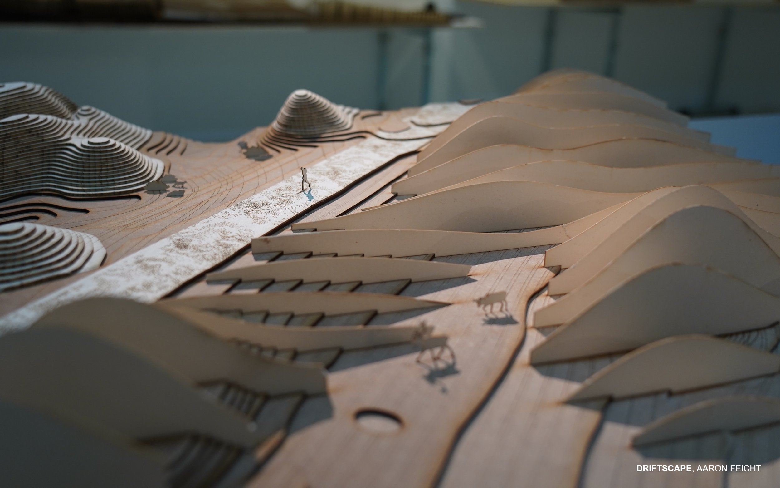
Figure 11. As part of the course, scale models were used systematically to explore and explain the proposed terrain modifications. In this example, a 1:100 model explains the spatial qualities of the new topography replacing and surrounding the former airstrip. In addition, different model techniques are applied to differentiate between a summer (left of path) and winter (right of path) situation. (Photo: Thomas Juel Clemmensen)
Å beholde en del av flystripen som et lineært landskapselement er en måte å erkjenne den nyere fortiden på, hvor mennesker har vært en geomorfologisk aktør. Som en motsetning til dette har den nye sanddynelignende topografien referanser til en fjernere fortid, da isbreene omformet landskapet rundt Svea (se figur 12).
I prosjektet møtes disse ulike fortidene, og man fremhever hvordan flystripen, og dessuten en mer omfattende del av landskapet, er formet både av menneskelig aktivitet og naturkrefter som erosjon og sedimentering.
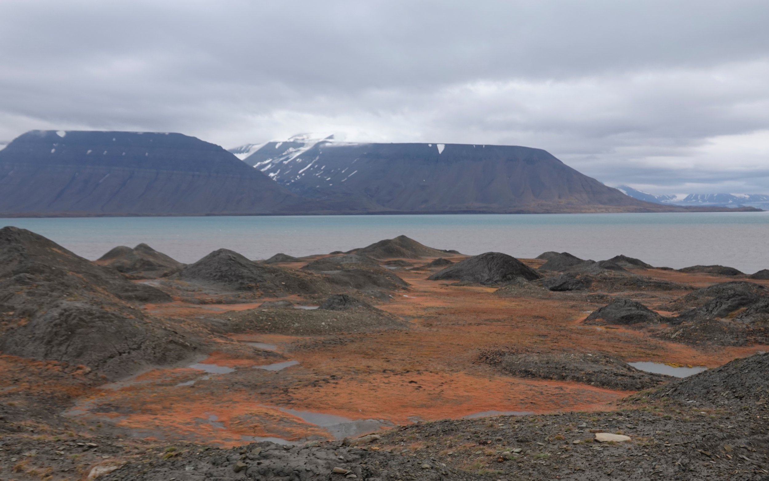
Figure 12. The dune-like topography proposed by Feicht is not foreign to the area. South of the mining settlement, one can experience a so-called kame and kettle topography resulting from a glacial surge approximately 600 hundred years ago. This unique topography forms when ice trapped inside the glacial deposits slowly melts. The airstrip was established on top of material from this glacial surge. From this perspective, it is interesting how this topography would re-emerge in a new form. (Photo: Thomas Juel Clemmensen)
Conclusion
Ideas of mining reclamation have changed since Smithson questioned the idea of returning mining areas to a pre-mining condition, but maybe not so much. Then considering the Svea reclamation project, the dream of recovering a wilderness, the Arctic being a new frontier, still seem to constitute an underlying ideal. This issue is partly due to the Svalbard Environmental Protection Act, but one thing is the wording of the act, and another is how it is interpreted. While removing harmful infrastructure and materials from this fragile environment makes perfect sense, the aesthetic agendas behind the operation are more questionable. Is this type of project the most appropriate response in the Anthropocene?
The student work presented here exemplifies an approach to mining reclamation that is just as environmentally responsible as the official project but without its ideological underpinnings that appear to be resting on a nature-culture divide. As a result, traces of mining activities are not by default seen as obstacles in the process of improving the ecological condition. Furthermore, the projects do not idealise the pre-mining landscape and add to the illusion that mining processes are reversible. Instead, they focus on nature-culture assemblages in the present landscape and explore how these can be integrated into future landforms, which benefit the local ecosystem and acknowledge this place's unique natural-cultural heritage.
All three projects work with open-ended design concepts without a predetermined result. This approach is not only in line with the actual dynamics of this landscape and the uncertainties following climate change but also reflects a particular attitude toward the design of landscapes, in which the site is treated as a kind of laboratory for gaining new insights aesthetically and ecologically.
Konklusjon
Det var i 1970-årene at Smithson stilte spørsmål ved om det var mulig å tilbakeføre gruveområder til sin opprinnelige tilstand. Siden den gangen har tenkningen endret seg, men kanskje mindre enn man skulle tro: Når man ser på restaureringsprosjektet i Svea, ser drømmen om å gjenopprette en villmark med Arktis som grenseland fortsatt ut til å være et underliggende ideal. Dette skyldes delvis Svalbardmiljøloven, men én ting er lovens ordlyd – en annen er hvordan den tolkes. Selv om det virker meningsfylt å fjerne skadelig infrastruktur og materialer fra dette sårbare miljøet, er den estetiske tanken bak arbeidet mer tvilsom. Er denne typen prosjekt det beste tiltaket i antropocen - menneskets tidsalder?
Studentarbeidet som presenteres her, eksemplifiserer en tilnærming til restaurering etter gruvedrift som er like miljømessig ansvarlig som det offisielle prosjektet, men uten dets ideologiske fundament, som ser ut til å hvile på et skille mellom natur og kultur. Resultatet er at spor etter gruvevirksomhet ikke i utgangspunktet ses på som hindringer i prosessen med å forbedre den økologiske tilstanden. Videre idealiserer ikke prosjektene landskapet slik det så ut før gruvedriften, og de bidrar ikke til illusjonen om at gruveprosesser er reversible. I stedet legger de vekt på sammensetninger av natur og kultur i det nåværende landskapet og ser nærmere på hvordan de kan integreres i fremtidige landskapsformer som gagner det lokale økosystemet og anerkjenner dette stedets unike natur-kulturarv.
Alle tre prosjektene arbeider med åpne designkonsepter uten et forhåndsbestemt resultat. Denne tilnærmingen er ikke bare i tråd med den faktiske dynamikken i landskapet og usikkerheten som følger med klimaendringene – den er også et resultat av en holdning til landskapsutforming der stedet behandles som et slags laboratorium som kan gi ny innsikt estetisk og økologisk.
References
Robert Smithson in an interview with Alison Sky (1973). See ’Entropy Made Visible’ in: Jack Flam (ed.), Robert Smithson: The Collected Writings (Berkeley, CA: University of California Press, 1996), 301–309.
The course was accomplished with competent support from teaching assistants Annie Breton and Kristján Breiðfjörð Svavarsson, ecologist Eva Breitschopf and architect Marc Ihle (Digital Landscapes).
See Section 64 (clean-up operations) in the Svalbard Environmental Protection Act
The idea of “nature-cultures” or nature-culture assemblages is borrowed from Rodney Harrison, professor of Heritage Studies at the Institute of Archaeology at University College London. See Rodney Harrison ‘Beyond “Natural” and “Cultural” Heritage: Toward an Ontological Politics of Heritage in the Age of Anthropocene’, Heritage & Society, 8:1 (2015), 24-42.
Robert Smithson is an important figure within art as well as landscape architecture. Smithson remains an essential reference, although he passed away almost 50 years ago – in 1973.
Entropy is a scientific concept and a measurable physical property most commonly associated with a state of disorder, randomness, or uncertainty. The term and the concept are used in diverse fields but were first recognised within classical thermodynamics. A consequence of entropy is that certain processes are irreversible or impossible Entropy is central to the second law of thermodynamics, which states that the entropy of isolated systems left to spontaneous evolution cannot decrease with time. Instead, they always arrive at a state of thermodynamic equilibrium, where the entropy is highest. See here.
In 1968 Robert Smithson did his famous earthwork Asphalt Rundown in a quarry outside Rome, Italy. See here. The work addresses time and the concept of entropy that emerged as one of the overriding concerns of Smithson's work. See ‘Introduction: Reading Robert Smithson’, in: Flam (ed.), Robert Smithson: The Collected Writings (Berkeley, CA: University of California Press, 1996), xiii-xxv.
Please note that the short descriptions in this essay do not justify the full scope and complexity of the original projects.